How to Locate Points on Site Using Ground Control Points
-
Locating exact positions on a construction site is crucial for accurate surveying, layout planning, and long-term project monitoring. Whether you’re mapping foundations, tracking progress, or verifying site boundaries, Ground Control Points (GCPs) play a central role in ensuring every coordinate aligns perfectly with real-world measurements. Modern job sites depend on these calibrated markers to maintain consistency and precision from start to finish.
In this guide, you’ll learn how GCPs work, why they’re essential in construction, and how to use them effectively to locate points with maximum accuracy.
Understanding the Role of GCPs in Construction Surveying
What Makes GCPs Important?
Ground Control Points are fixed reference markers placed strategically around a project site. Each marker contains precisely measured coordinates collected using high-accuracy GNSS or total-station equipment. These coordinates anchor your drone maps, ground surveys, and layout tasks to the correct global position.
Without these reference points, measurements can drift, leading to misaligned foundations, incorrect elevation levels, and costly rework.
Where GCPs Are Commonly Used
-
Road construction
-
Mining and quarry sites
-
Commercial building projects
-
Land development and grading
-
Utility placement and trench mapping
In all these cases, GCPs provide the reliable spatial alignment needed for decision-making and documentation.
How GCPs Help You Locate Points on a Construction Site
1. Establishing Baseline Accuracy
Before any drone flight, scan, or stakeout, surveyors set up site control markers your GCPs to establish a stable coordinate system. These points become the “truth” against which all future measurements are compared.
2. Using GCPs With Drone or Ground Surveys
Drone maps alone can be slightly off due to GPS drift. But when paired with GCPs:
-
Orthomosaics align with real-world coordinates
-
Elevation models reflect true site levels
-
Measurements such as distances and volumes become highly reliable
This allows surveyors to locate any point corner pins, excavation zones, slab edges—within centimeter-level accuracy.
3. Locating Points With GNSS Receivers
Once your GCP network is established:
-
Load GCP data into your survey controller
-
Navigate to the point you need to stake out
-
Use your rover to position yourself relative to the calibrated GCP coordinate system
This ensures all layout points match the original site plans perfectly.
Best Practices for Setting Up GCPs on a Construction Site
Choose the Right Locations
Place your survey targets where:
-
They have clear sky visibility
-
Heavy machinery won’t disturb them
-
They cover the entire working area
-
They avoid shadows or obstructions
Spacing them evenly helps maintain mapping accuracy across the site.
Keep Markers Secure
Use:
-
Painted wood boards
-
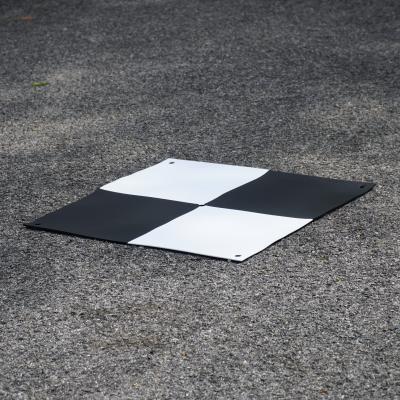
Checkerboard tiles
-
Weather-resistant plastic targets
-
Weighted rubber mats
Secure markers to prevent movement from wind, vehicles, or site activity.
Ensure High-Quality Coordinates
Accurate measurements depend on:
-
RTK or PPK GNSS methods
-
Double-checking coordinate values
-
Recording metadata (date, time, equipment used)
Small errors at this step can affect the entire project.
H3: Using GCPs for Repeated Site Surveys
For ongoing projects like quarries, highways, or large building sites—fixed GCPs allow you to map progress over weeks or months. Because the coordinate system remains consistent, you can measure:
-
Cut-and-fill volumes
-
Stockpile changes
-
Building progress
-
Utility placements
-
Changes in elevation
This repeatability is what makes GCPs essential for long-term construction monitoring.
Common Mistakes to Avoid
Avoid These Errors
-
Placing all markers in one area
-
Using low-contrast targets
-
Setting GCPs too close to moving equipment
-
Not re-checking coordinates after heavy site activity
-
Relying only on drone GPS without any reference markers
Correct placement and consistent use are key to reliable data.
Final Thoughts
Using Ground Control Points correctly can transform the accuracy of your construction surveys. From establishing reliable baselines to ensuring repeatable measurements, GCPs act as the backbone of precise site mapping. When combined with GNSS receivers, drones, or total stations, they help you locate and verify any point on the construction site with confidence.
Reliable measurements lead to better planning, fewer reworks, and smoother project execution making GCPs one of the most valuable tools in modern construction surveying.
-